Spontaneous road-trips, followed by little-planned hikes, will one day be the death of my vehicle. I think one of the biggest mistakes I made in my twenties was my decision to buy my Civic. With my bad university credit not yet buried behind me, my payments are outrageous (thanks, subprime!) and the car is just entirely all wrong for me. First of all, I like to take my dog places. This car is a two-door, non-hatchback style--meaning it is all but impossible to save both front and back seats from the wrath of my mutt, Ella. Cover one seat, and she's bound to choose the other to land on. Secondly, my '09 model is about as low as a car should ever be legally allowed to get in Cape Breton. Just in my regular driving alone, which admittedly includes a few bumper scrapes in Sydney, I've managed to tear off a front fender clip, then months later lose the entire fender (fell off because of snow drift, plus said clip), and split my windshield washer tank. While the coupe's fuel economy is admirable, it is not the best road-tripping vehicle for some of the more rural parts of the island.
 |
| Thank God for travel companions who think to check the depth of pot-holes. Here is Russell throwing stones on the road ahead. |
Today, however, that car made me proud--enough to continually discuss names for her on the route. I'm not naturally a namer of cars. At least, I don't have the passion and discipline required to perfectly name a car, then stick with that name (most of my vehicles have had several names over their lifetimes). This particular route that elicited so much car-love was the trek up Bald Mountain, past the end of Big Baddeck Road in Big Glen. We took Sandy? Gerry? (I've forgotten already) to places she should never have gone--several times in the wrong direction, then too far in the right direction). An online description suggests the trailhead is at N 46° 14.139 W 060° 40.969, with the trail starting to the WEST of this location, but my GPS did not seem to want to keep up with me on this day. In any case, we eventually found ourselves on track.
For the end of April, there was still a great deal of snow in some places, and we found ourselves too far into a classic road-that-turns-into-an-ATV-path to turn around. We continually spoke of our stupidity for not bringing our X-Terra instead, our gas-guzzling 4-wheel drive titan. In any case, we made it past the snow, high water, and washed-out sections of road to make it to McMillan cemetery.


We decided to park here, at this entirely unexpected cemetery. I hadn't read about it when I decided to go to Bald Mountain, but I still had it programmed into my GPS from my last cemetery tour of Baddeck (there are a series of geocaches planted at cemeteries all over Baddeck, and some are way off the beaten path). On that day, we spent a full eight hours or so searching out cemeteries, and never came close to this one, so we left it off the list. I was happy for this chance stumble-upon, and to see some of the older graves at this site in the middle of nowhere.
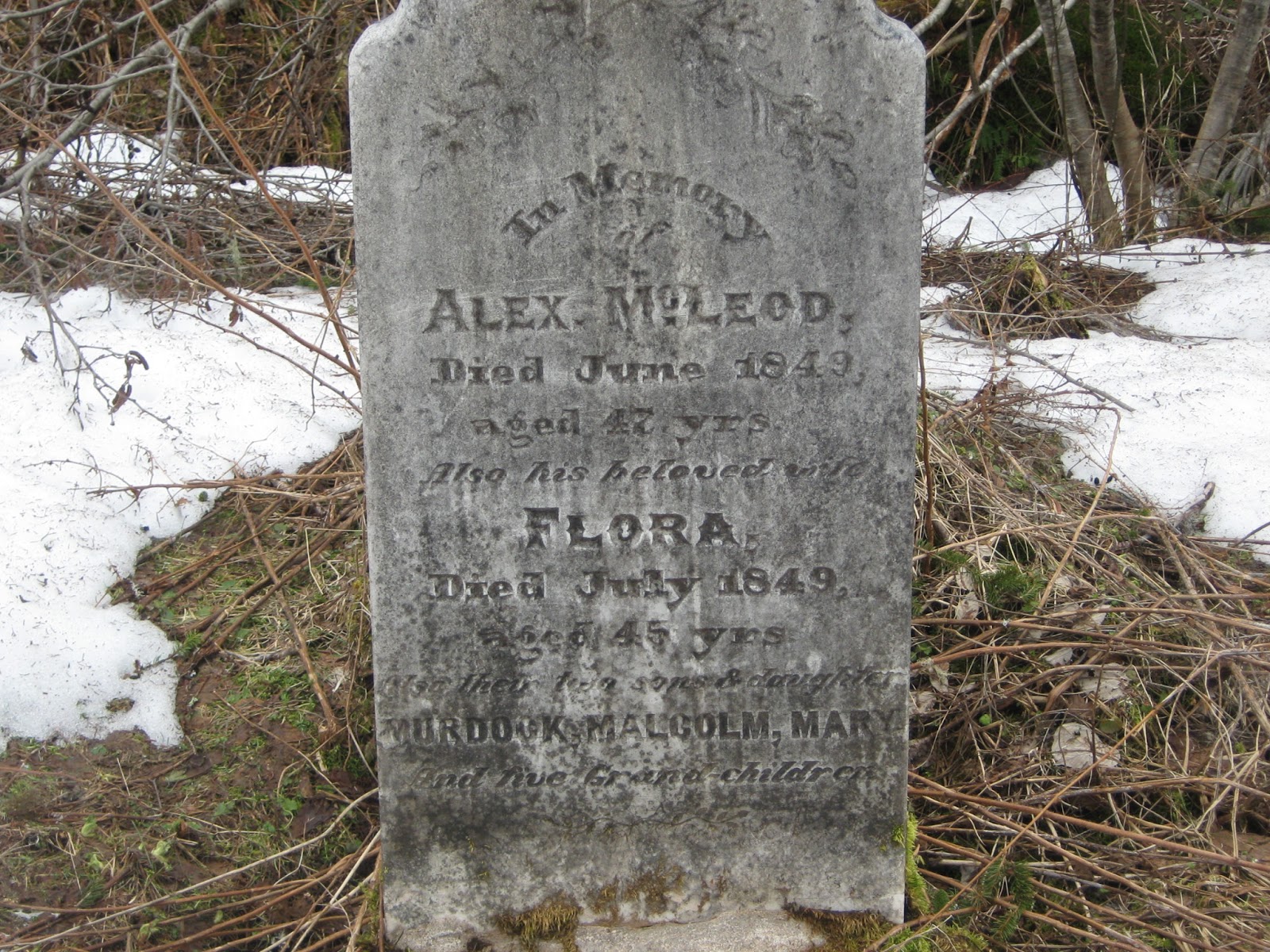 |
| I wanted to name the car Alex, after the person to whom this headstone belongs, but that's also the name of Russell's boss, so he vetoed the idea. |


 |
| Me, wringing out my socks. |
Geocaches in area:
"McMillan Cemetary" N 46° 13.733 W 060° 41.598 Status: Good (4/6/13) GC2X6R2
Trek to Bald Mountain 1 of 4" N 46° 14.206 W 060° 41.168 Status: Good (4/6/13) GC2YDMG
"Trek to Bald Mountain 2 of 4" N 46° 14.524 W 060° 41.504 Status: Good (4/6/13) GC2YDMC
"Trek to Bald Mountain 3 of 4" N 46° 14.927 W 060° 41.480 Status: Good (4/6/13) GC2YDM5
Trek to Bald Mountain 1 of 4" N 46° 14.206 W 060° 41.168 Status: Good (4/6/13) GC2YDMG
"Trek to Bald Mountain 2 of 4" N 46° 14.524 W 060° 41.504 Status: Good (4/6/13) GC2YDMC
"Trek to Bald Mountain 3 of 4" N 46° 14.927 W 060° 41.480 Status: Good (4/6/13) GC2YDM5
"Trek to Bald Mountain 4 of 4" N 46° 15.269 W 060° 41.379 Status: Good (4/6/13) GC2YDKT
"Why We Cache" N 46° 15.350 W 060° 41.234 Status: Good (4/6/13) GC2YDKF
"The Lookoff" N 46° 15.493 W 060° 41.152 Status: Good (4/6/13) GC2X6PB
"Bald Mountain Summit" N 46° 15.918 W 060° 41.143 Status: Good (4/6/13) GC3N0CG
"Why We Cache" N 46° 15.350 W 060° 41.234 Status: Good (4/6/13) GC2YDKF
"The Lookoff" N 46° 15.493 W 060° 41.152 Status: Good (4/6/13) GC2X6PB
"Bald Mountain Summit" N 46° 15.918 W 060° 41.143 Status: Good (4/6/13) GC3N0CG
There are other Cemeteries up there that are not even marked with a sign, old collapsed homes, former school site. The locals today either don't care not know about it. I've become obsessed with that place so much that I want to buy the entire valley. https://youtu.be/JIKaBCzPDk0
ReplyDelete